

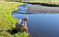
Geoscientists Michael Rawlins, analyzed 44 years of data. (Mike Rawlins via SWNS)
By Stephen Beech
An area of Alaskan permafrost the size of Greece is thawing, reveals new research.
Arctic and global climate patterns may never be the same as a result, scientists warned. As temperatures rise, the Arctic is warming around four times faster than the rest of the planet, accelerating these changes.
When permafrost is perma-lost, they say the global carbon cycle is altered and coastal ecosystems are affected. This thawing process is already hastening the release of greenhouse gases from the permafrost—a vast, frozen store of carbon that could trigger a significant warming feedback loop.
The first study of its kind has shown in fine detail what happens when Arctic permafrost thaws. Researchers focused on an area of Alaska’s North Slope, containing hundreds of rivers and streams flowing into the Beaufort Sea, which is around the same size as the U.S. state of Wisconsin or Greece.
The team, led by geoscientist Professor Michael Rawlins, analyzed 44 years of data at 1-kilometer grid resolution. The study revealed how massively runoff is increasing, the increased loads of previously frozen carbon flowing through northern Alaska’s rivers, and how the thawing season has extended into late summer and autumn.

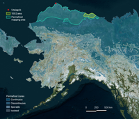
Alaska Science Center / U.S. Geological Survey
Scientists say their findings, published in the journal Global Biogeochemical Cycles, help us better understand just how one of the fastest-warming parts of the world is rapidly changing. They explained that Arctic rivers are a key part of Earth’s ecosystem, delivering 11% of the world’s river water to an ocean that contains just 1% of the world’s ocean volume.
While much of the river water comes from melting snow, permafrost thaw also plays a key role. Dr. Rawlins says “permafrost” is something of a misnomer because there is a part called the “active layer” which freezes and thaws again every year. He explained that the active layer has been deepening in recent decades, causing proportionally more groundwater to be delivered into Arctic rivers.
The active layer also contains vast stores of frozen organic carbon. When the active layer deepens, more of that carbon, in the form of dissolved organic carbon (DOC), washes into the rivers and, ultimately, the ocean. The Arctic Ocean receives a disproportionate share of the DOC delivered from rivers worldwide, and more than 275 million tons of that carbon gets released as planet-warming carbon dioxide every year.

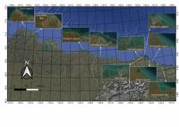
A satellite map of the Alaskan North Slope coastline highlighting various drainage basins and lagoons including Elson Lagoon, Simpson Lagoon, and Kaktovik Lagoon for permafrost research. (Mike Rawlins via SWNS)
The research team wanted to know how individual rivers, and even small streams, are faring as the world warms. Dr. Rawlins, of the University of Massachusetts Amherst in the U.S., said: “What makes this question so hard to answer is that direct observations are very sparse in northern Alaska.”
He explained that one way to get around the paucity of data is with a model—the more precise the better. Dr. Rawlins has spent the last 25 years developing the Permafrost Water Balance Model to get the best possible estimate of what is happening out in the field. This type of modeling is essential since scientists often find ancient remains stored in permafrost along these remote rivers, highlighting the long-term preservation of carbon and organic matter now at risk.

(Photo by TonyNojmanSK via Pexels)
In 2021, he expanded the model to simulate DOC, and in 2024 he and his colleagues modeled 22.45 million square kilometers of Arctic land. The team found that over the next 80 years the region would see up to 25% more runoff and 30% more subsurface runoff.
Dr. Rawlins said: “This new study is the first time anyone has captured such a wide area of the Arctic—about the size of Wisconsin—down to the kilometer scale.” The data suggests these shifts could significantly impact Arctic food webs as the timing of freeze-thaw cycles shifts.
He says it took a supercomputer 10 continuous days to crunch the data for each run. Scientists are also now using fiber optic cables to track seafloor permafrost and identify carbon-rich “seeps” that indicate further warming.
Dr. Rawlins said: “Our freshwater and DOC inputs to coastal estuaries will be useful to a broad range of stakeholders interested in these unique ecosystems.”

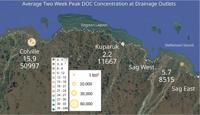
A scientific data map showing average peak dissolved organic carbon (DOC) concentrations at Alaskan drainage outlets like Colville and Kuparuk, using color-coded circles to represent milligrams per liter. (Mike Rawlins via SWNS)
The team discovered the largest increases in DOC export are emanating from northwest Alaska. Dr. Rawlins said: “It’s flatter over there, which means there’s much more carbon from decaying matter in the permafrost that has been accumulating for tens of thousands of years. This is ancient carbon.”
Dr. Rawlins says the most surprising discovery was how thawing of the permafrost is driving much of the change—and the thaw season has extended into September and even October. He said these shifts are likely altering salinity and biogeochemical processes in the coastal Beaufort Sea.
He added: “We desperately need more of these land-to-ocean connection studies if we’re to fully grapple with the problem of global warming and the effects it will have on coastal ecosystems.”