
Lake effect snow can unleash 1-2 inch snowfall rates.
CLEVELAND — Lake effect snow is in the forecast for parts of Northeast Ohio through the Thanksgiving holiday. This lake effect snow event could produce intense lake snow bands capable of 1-2 inch snowfall rates per hour. The science behind those sudden whiteout bursts often a product of a tightly tuned atmospheric engine fueled directly by the Great Lakes.
This setup begins when cold air masses sweep across Lake Erie. In December and early January, Erie remains one of the warmest Great Lakes. That temperature contrast between the cold air above and the warm water below creates the instability needed for powerful lake effect bands.
The frigid air crosses the lake, it rapidly picks up heat and moisture from the exposed surface. This exchange triggers the process of condensation or narrow columns of clouds. When the temperature difference between the lake surface and the air at roughly 5,000 feet exceeds about 23 degrees, the atmosphere becomes primed for vigorous convection. That convection is what drives the explosive snowfall rates.
Wind direction determines who gets hit. A west-southwest flow is most common late-fall and early-winter patterns. The setup lines up with the longest fetch across Lake Erie and directs the most intense band into the snowbelt of Lake, Geauga and Ashtabula counties. Under this alignment, rising air columns can stretch thousands of feet deep, similar to miniature thunderstorms, producing rapid snow crystal growth and heavy accumulation in short bursts.

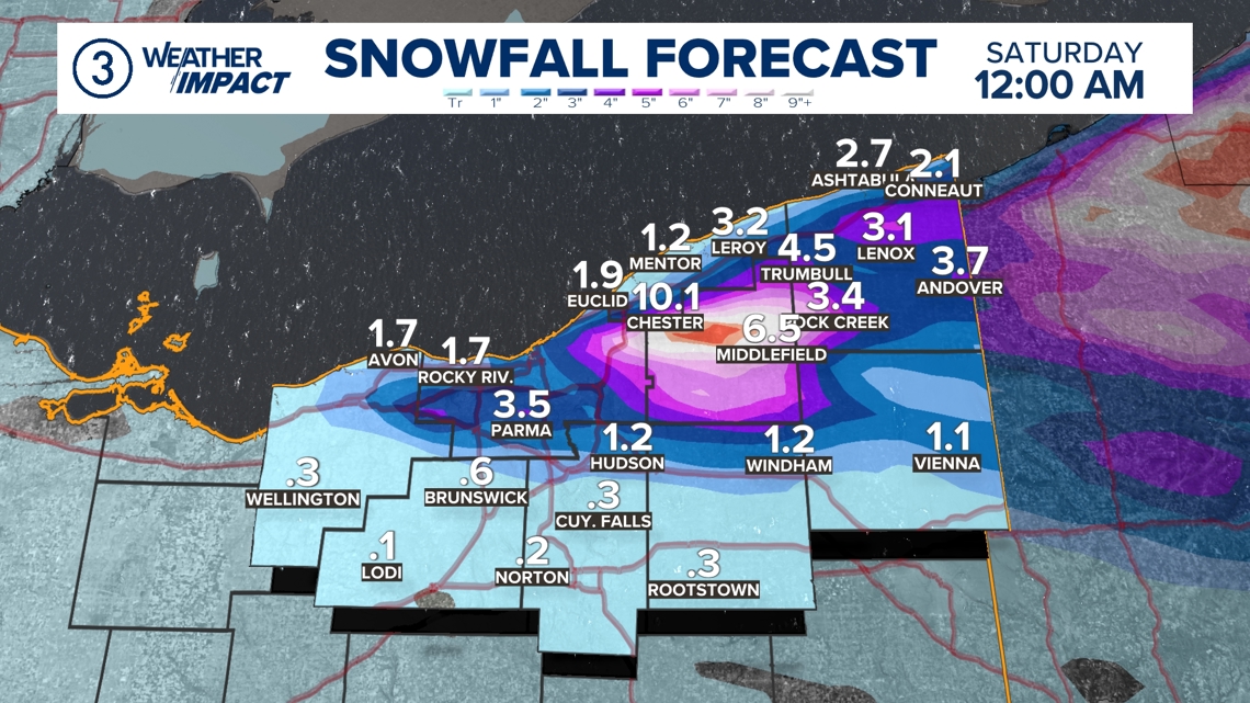
Topography enhances the effect. Northeast Ohio’s higher elevations areas like Chardon Ridge and the higher terrain east of Cleveland force the moist air upward, squeezing out even more snow. This orographic lift is why communities just 10 miles apart can see dramatically different totals.
When winds stay aligned for several hours, the band can sit nearly stationary, allowing those 1–2 inch-per-hour rates to stack up quickly. Commuters can leave downtown Cleveland under light flurries and find themselves in near-zero visibility only minutes later as they travel under a band’s core.
These high-rate events can remain a defining impact of the winter as long as the lake stays unfrozen and cold-air intrusions continue to charge across it.